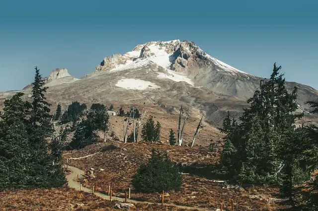
Mount Hood is the most popular snow-covered peak in America, and it’s not hard to see why.
Not only is it one of the easiest glacier-covered mountains to summit, it also has a ton of beautiful trails that extend partially up the mountain and into the surrounding wilderness. Visitors of all ages and levels of physical ability will find a trail that suits them.
While there are dozens of trails in the Mount Hood area, some are honestly better than others. This article will list the most popular Mount Hood hiking trails and allow you to make the most of your time at Mount Hood by prioritizing the most beautiful and interesting hikes.
Old Salmon River Trail
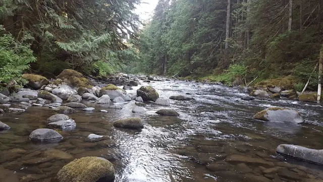
If you enjoy walking through old-growth forests, the Old Salmon RIver trail is an excellent choice. Hanging moss swings lightly from the majestic cedar trees that line the trail. It’s a pretty easy hike too ‒ at just 2.1 miles, walking the Old Salmon River is a really great way to experience the beautiful environment near the base of Mount Hood without investing in a day-long trip.
Although the trail has pretty easy access from the town of Zigzag, you’ll need $5 for a Northwest Forest parking pass if you haven’t purchased one yet.
McNeil Point Trail
The McNeil Point trail is a rather difficult 4-mile hike to the picturesque McNeil Point. For the best weather and scenery, you’ll want to tackle this hike in either the spring or early autumn. Some of the scenery that make this hike so worthwhile include a colorful array of wildflowers, a few gorgeous brooks, and some incredible views of Mount Hood and the surrounding mountain landscapes.
Parking at the beginning of this trail also requires a Northwest parking pass, so make sure to buy one before you go.
Tamanawas Falls Trail
The Tamanawas Falls trail is named after the tamanawas, which is what the Northwest Indians who used to inhabit the Mount Hood area call the friendly guardian spirit that protects people from harm.
The highlight of this trail is the 100-foot waterfall at the base of the mountain. It’s also pretty easy to get to, as the 1.9 mile trail is level and relatively free of elevation changes. It also has a number of picturesque footbridges, making it a great spot for taking pictures of the rivers and falls.
Pacific Crest Trail
If you’re into gorgeous canyon views, walking the segment of the Pacific Crest trail that leads to the Zigzag Canyon overlook is a must-do hike. The 700-foot canyon, carved by the aptly-named ZIgzag river, is one of the highlights of the Mount Hood area. The short trail length and easy terrain should give it a spot on your itinerary, regardless of your fitness level or time constraints.
Note: Unless you’re in the mood for some more serious hiking, I recommend turning back around when you reach the canyon. The trail goes on for much longer than the canyon stop, and hikers who are unprepared would be wise to turn back.
Cooper Spur
The Cooper Spur trail is the highest hiking trail on all of Mount Hood. If you want to progress higher up the mountain than this trail allows you, you’ll need to bring some ice climbing gear and a tent. In fact, many people who do intend to climb one of Mount Hood’s glaciers typically start out by taking the Cooper Spur route.
One of the most compelling reasons to hike the Cooper Spur trail is to take in the jaw-dropping views provided by the high vantage point. If you reach the peak of the Cooper Spur path, you’ll be greeted by the magnificent peaks of Mount Rainier and the Three Sisters. You’ll also get to view the Eliot Glacier from above, which takes the form of a frozen river of ice.
The major downside of the Cooper Spur trail ‒ or upside, depending on your perspective ‒ is that it requires you to conquer a whopping 2,800 feet of elevation gain. While many of the hikes that surround Mount Hood are suitable for anyone regardless of age or fitness level, the Cooper Spur hike is something best left to those in pretty good physical shape. Visitors with less than stellar fitness levels are free to attempt the hike ‒ just be prepared to turn back if the going gets too tough.
If you do want to view the Eliot Glacier from a bird’s eye view without the grueling climb, there is an easier option. There’s also a 1.3 mile hike with more reasonable elevation gain that will still give you a pretty good view of the ice river.
Like many of the hikes on this list, summer and early fall are the best times to tackle this.
Trillium Lake Loop Trail
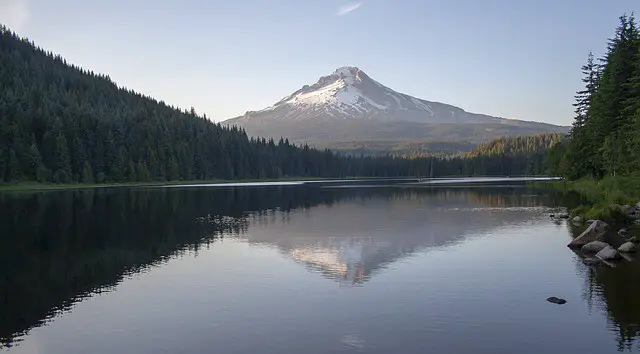
Trillium Lake is the closest lake to Mount Hood. Hiking to this lake will give you a wonderful vantage point for unobstructed pictures of the mountain. This ideal picture spot is even better on calm days when the lack of wind allows for a mirror image of the mountain to reflect off the lake’s surface. The trail is also extremely easygoing ‒ the 2-mile round trip and extremely flat surface make it possible for people in wheelchairs to make the journey.
True to its name, this trail loops around the lake, which makes it an excellent choice for those who prefer the sight of water to being surrounded by trees. The area in which you begin the hike has some nice picnic spots, so bring some food with you, even if you don’t think you’ll need it for the easy hike. The fishing dock is also a great place to launch a canoe from, so boat owners will find this hike more attractive than many of the others on this list. Just know that you can’t bring a motorboat ‒ the organization in charge of the Mount Hood area has banned them, presumably to preserve the natural tranquility of the area as well as to reduce pollution.
If you are planning on visiting the Trillium Lake Loop trail, you should know that it is closed during the off-season. The trail usually opens to the public in May. If you have some flexibility in planning your trip, I recommend going in the summer or early fall, as that’s when the weather is best and the scenery is at its most beautiful point.
Elk Meadows
The eastern side of Mount Hood boasts a number of picturesque meadows. One of these is Elk Meadows, and the trail that leads to it is nothing short of breathtaking.
You’ll start off in a forest of hemlock and fir trees. This portion of the trail ends rather quickly, so many people choose to linger here and enjoy the quiet atmosphere before moving on. Once you do leave the forest, you’ll come to a pair of bubbly creeks, which are followed by a slow march up Newton Canyon.
When you reach the top of the slope leading up the canyon, you’ll come to Elk Meadows. This point in the trail is one of the best photography opportunities in the Mount Hood area. The wavy grasses dotted with violet flowers make a beautiful foreground for the clear view of the eastern slope of Mount Hood directly behind them. Once you’ve taken in the sights, there’s another worthwhile lookout point with a great view of Elk Mountain that you can check out.
If you like picnicking or camping, Elk Meadows has plenty of spots for both. You’re also a moderate 6-mile hike to Tamanawas Falls, which is another terrific camping spot.
Paradise Park
If you’re looking for a hike with a comfortable and convenient start point, the Paradise Park trail is definitely one to consider. The trail begins at Timberline Lodge, making it a great place to grab some food or drink after a solid day of hiking.
Convenience is far from the only reason you should go on the Paradise Park hike though. The end destination and the journey to it are both packed with gorgeous scenery and nature scenes. The path to Paradise Park is dotted with hemlock and mountain ash, and leads directly past Zigzag Canyon. Hikers who aren’t too comfortable with significant elevation changes might want to turn back at this point, as the next leg of the trail will take them down 1,000 feet into the canyon.
If you’re up for the challenge, the destination is definitely worth it though. After dropping into and crossing the Zigzag chasm, you’ll climb about 1,200 feet to reach the meadows of Paradise Park. Dozens of different kinds of flowers populate these meadows, so naturalists will find this section of the hike particularly enjoyable.
There are also a number of beautiful campsites to choose from, so adventurous folks who don’t want to spend a night in the Mount Hood wilderness should give Paradise Park a shot.
Gnarl Ridge
Gnarl Ridge is one of the longer and more difficult climbs in the Mount Hood area. At more than 8.2 miles and 2,000 feet of elevation gain, many visitors will be hard-press to complete this hike without camping overnight.
Despite the relative difficulty of the climb, the views offered by Gnarl Ridge more than make up for the additional physical effort. Unobstructed views of Mount Hood, Mount Jefferson, the Three Sisters, and other peaks are visible from the higher portions of the trail.
If you do plan on spending the night, you should consider taking the Timberline Trail once you come to it. There are a few cleared spots along this path that will make for easy camping.
Owl Point
The trail leading to Owl Point is marred by the remnants of a wildfire known as the Dollar Lake fire. Caused in 2011 by a lightning strike, this fire destroyed countless acres of pristine forest ‒ and the effects are still very much visible today.
The path to Owl Point begins at the Vista Ridge Trailhead Junction, though you’ll have to walk about a half mile through a fir forest to get here. One of the nice things about this hike is that yo get to see your end destination relatively early. Less than a mile into the hike, you’ll come to a spot that gives you a clear view of both Owl Point and the peak of Mount Hood. This spot will also give you a broader view of the wildfire’s devastating effects.
Walk about three quarters of a mile beyond this point, and you’ll come to the intersection that takes you to Owl Point. Make your way to the top of the Point and enjoy the spectacular views. And if you’re not in a rush, you can check out the weather-protected registry box. Inside are some older photos of Mount Hood and the surrounding valley, which will give you a pretty good idea of how the area looked before the wildfire.
This article is owned by Recapture Nature and was first published on August 19, 2019
Hunchback Mountain
The Hunchback Mountain trail is another good choice for visitors looking for easy access from the town of Zigzag. The beginning of the hike takes you through bunches of wildflowers before starting on a sharp incline.
In addition to the easy access, this hike also passes by three beautiful lookout points. The first lookout point provides a view of the Salmon River, the Salmon River Valley, and the Salmon-Huckleberry Wilderness beyond it. If you come during the right time of the year, you might catch sight of some salmon jumping out of the water in the distance.
The next lookout point is called Rockpile, and stopping here will give you the first full view of Mount Hood on the Hunchback Mountain hike. Many visitors choose to make Rockpile their turnaround point, as it’ll take another couple of miles of moderately hard hiking until you reach the third and final lookout point.
If you do decide to continue on the hike, the third lookout point, called the Great Pyramid, lies about two miles beyond the Rockpile stop. If you enjoyed the view from the first lookout point, making it to this one is certainly worth the effort. You’ll get a broader, fuller view of the Salmon River and the Salmon-Huckleberry wilderness. If the skies are clear, you can even catch a glimpse of Mount St. Helens jutting out of the ground to the northwest.
Muddy Fork
The hike to Muddy Fork is an interesting one. As you make your way to this scenic section of river, you’ll pass by glaciers, waterfalls, rivers, and even a volcano. The endpoint of the hike is even better than the journey though, as you’ll get a fantastic bottom-up view of Sandy Glacier, as well as the three waterfalls that fall from the glacier to feed Muddy Fork.
This article is owned by Recapture Nature and was first published on August 19, 2019
The difficulty of the hike is moderate, with about 5.5 miles distance and significant elevation gain. Most able-bodied hikers should be able to complete the trail in a few hours, though there are additional trails that branch off from this one if you want to extend your hike and explore the area further.
Bald Butte Hike
Bald Butte is considered a local natural wonder ‒ and a visit to this pristine spot makes it easy to see why. The Butte is situated exactly where the western sea air meets the dry eastern air. This ecological collision point makes this location the perfect place for all kinds of unique wildflower growth.
At 8.4 miles, the Bald Butte hike is not a trip that should be made without proper preparation. Though it’s technically considered a “there and back” trip, slower walkers should consider turning back before reaching the endpoint.
Bonney Butte
The Bonney Butte hike is unique amongst Mount Hood trails in that there is actually some regular activity occurring at the trail’s end. This activity comes in the form of HawkWatch International, who use Bonney Butte as a staging ground for tracking and banding the hawks that live in the Mount Hood area. You’re almost guaranteed to run into groups of bird watchers if you make the Bonney Butte hike during peak birding season.
If you’re interested in learning more about the raptors in the area, there is no better place to do that than at Bonney Butte. If you visit during the monitoring season ‒ which runs from the end of August to the end of October ‒ you’ll get the chance to both learn about and look at golden eagles, red-tailed hawks, turkey vultures, sharp-shinned hawks, and other predatory birds.
This article is owned by Recapture Nature and was first published on August 19, 2019
If you’re more interested in expansive views than birds, Bonney Butte is still worth the hike. You’ll get a crystal clear view of Mount Hood, Mount Adams, and some of the peaks located in the center of Oregon. The hike also has numerous campsites, making it an excellent spot to pitch a tent and enjoy the nighttime sounds that emanate from the mountain and the surrounding wilderness.